Overview
Sam Otto – Crestaurum-Barney Deposits Overview
Sam Otto & Crestaurum
The Sam Otto and Crestaurum gold deposits are two advanced exploration targets on the Yellowknife City Gold project located on the same mineralized system as the past producing Con and Giant mines which have produced a total of 14 million ounces of gold.
In November 2019, Gold Terra published its first mineral resource estimate on the property. The mineral resource encompasses four deposits (Sam Otto, Crestaurum, Barney and Mispickel) within a three kilometre radius. It incorporates the results from 463 drill holes totaling 90,751 m, from which 201 drill holes totaling 42,447 m were completed by Gold Terra from 2014 to 2019.
Expansion of the Sam Otto open pit and Crestaurum underground resources was the main focus of the 2020 drilling program. The 2021 mineral resource update includes an additional 59 holes totaling 17,540 metres from drilling completed in 2020 on the Crestaurum and Sam Otto deposits.
On May 15, 2026, the Company released an updated Mineral Resource Estimate (“MRE”) on the Yellowknife Project, which included the Yellorex Zone and Zone 103N of the Con Mine Option Property, and the Crestaurum deposits of the YP.
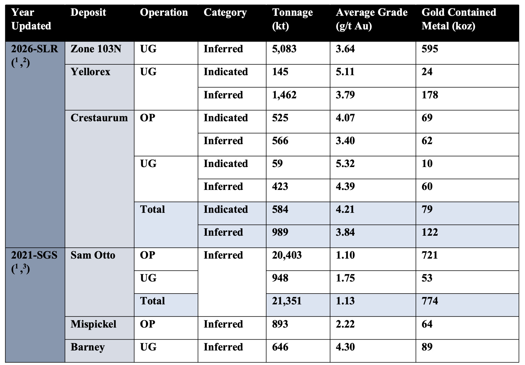
Consolidated Mineral Resource Estimate
The MREs of Gold Terra, including the SLR updates of Yellorex and Crestaurum, as well as the initial MRE of Zone 103N, are combined with the SGS 2021* MREs of Sam Otto, Mispickel (currently referred to as Pickle) and Barney in the table below:
(* The October 21, 2022, technical report, titled "Initial Mineral Resource Estimate for the CMO Property, Yellowknife City Gold Project, Yellowknife, Northwest Territories, Canada" with an effective date of September 2, 2022, was prepared by Dr. Allan Armitage, P.Geo. from SGS, an Independent Qualified Person as defined under NI 43-101. (see Gold Terra Oct 21, 2022, Technical Report).
Gold Terra Consolidated Mineral Resource – Effective date of April 30, 2026, and March 14, 2021:
Notes:
- CIM (2014) definitions were followed for Mineral Resources.
- SLR-2026:
- Mineral Resources are estimated above the following cut-off grades:
- Zone 103: 2.0 g/t Au
- Yellorex: 2.2 g/t Au
- Crestaurum: 0.7 g/t Au (OP); 2.2 g/t Au (UG)
- Mineral Resources are estimated using a long-term gold price of US$2,600 per ounce, and a US$/C$ exchange rate of 1.35.
- Bulk density in domains ranges between 2.65 t/m3 and 2.85 t/m³.
- Metallurgical recovery for gold is 90%.
- A 50 m crown pillar beneath the lake, measured from the base of the overburden, is applied at Yellorex.
- Mineral Resources are reported within an optimized pit shell and/or Deswik Stope Optimizer (DSO) underground resource panels.
- A minimum mining width of 1.5 m is applied to underground resources; and 4 m for open pit resources.
- Mineral Resources are estimated above the following cut-off grades:
- SGS-2021:
- Sam Otto and Mispickel deposits may be mined using open pit mining methods. Open pit mineral resources are reported at a cut-off grade of 0.4 g/t Au within a conceptual pit shell. Sam Otto and Barney deposits may be mined using underground bulk mining methods. A selected cut-off grade of 1.4 g/t Au is used to determine the underground mineral resource for the Sam Otto/Dave’s Pond deposit and 2.0 g/t Au for the Barney deposit (assuming it can be accessed underground from the Crestaurum deposit).
- High grade capping was done on 1 m composite data. Capping value of 60 g/t Au was applied for Mispickel.
- Cut-off grades are based on a gold price of US$1,500 per ounce, a gold recovery of 90%, processing cost of $US16.00 per tonne milled, and variable mining costs including $US2.20 for open pit and $US 44.00 to 79.00 for underground. The cut-off grades should be re-evaluated in light of future prevailing market conditions (metal prices, exchange rates, mining costs etc.).
- Specific gravity values were determined based on physical specific gravity test work from each deposit: Barney at 3.00 t/m³; Sam Otto and Mispickel at 2.80 t/m³.
- Metallurgical recovery for gold is 90%.
- No crown pillar applied beneath the lake.
- All Mineral Resources are presented undiluted and in situ, constrained by continuous 3D wireframe models, and are considered to have reasonable prospects for eventual economic extraction.
- Numbers may not add or multiply accurately due to rounding.
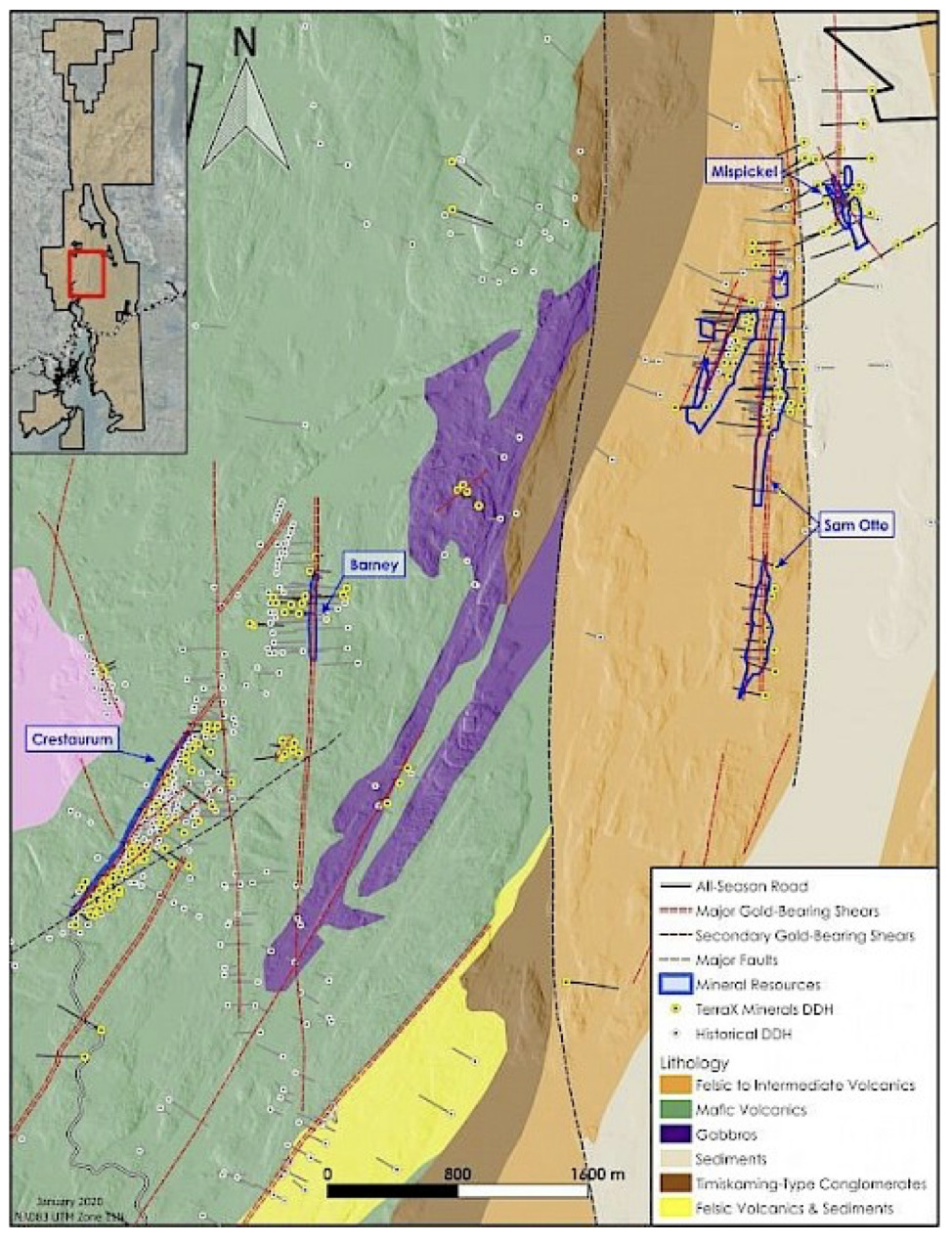
Sam Otto
The Sam Otto area is a large gold mineralizing system found on the property to date. The dominant north-south mineralized system extends for approximately 4.5 km over widths of 80 to 130 m. Gold Terra has completed 26,694 m of drilling in 94 holes on Sam Otto from 2016 to 2020.
The Sam Otto deposit consists of three zones – Sam Otto Main, Sam Otto South, and Sam Otto West (Dave’s Pond) which are hosted in felsic to intermediate volcanics of the Banting Formation with intercalated sediments and mafic volcanics. The Sam Otto Main and South consist of north-south trending zones of gold mineralization which are vertically to steeply east dipping and occur in discrete 2 to 20 m wide shear zones with sericite alteration and minimal quartz veining. These shear zones are crosscut by northeast structures that create significant higher-grade shoots with indications of increasing grade with depth. Gold is associated with disseminated sulphides (minor to low percentages of pyrite, pyrrhotite, and arsenopyrite). Visible gold is rare and gold grades are consistent within a range of 0.5 to 5 g/t (no gold assays > 25 g/t).
The Sam Otto West zone (Dave’s Pond) trends north-northeast and consists of narrow discrete shear zones (3 to 10 m in width) of moderate to intense quartz-sericite-carbonate alteration with multi-stage quartz veining and moderate sulphides (arsenopyrite, pyrite, and stibnite) associated with the gold. Visible gold is more common and gold grades range from 3 to 15 g/t with assay values up to 30 g/t.
Sam Otto
- A large deposit containing a pit constrained Inferred mineral resource of 426,000 oz gold (10,794,000 tonnes averaging 1.23 g/t) to a maximum depth of 200 m
- Highly prospective bulk tonnage target with wide shear-hosted gold mineralization traced over a strike length of 4.5 km
- 2020 drilling program successfully expanded the mineralized system, which remains open to the north, south and at depth.
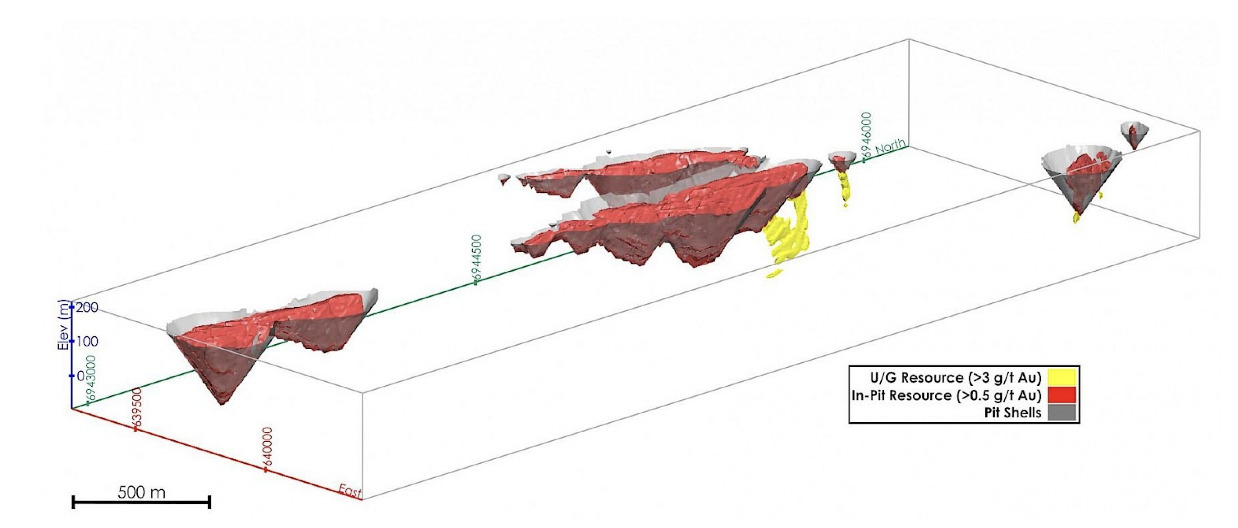
Sam Otto Pit Shell
Barney
The Barney deposit is located 1 km northeast of Crestaurum on a north-south trending deformation zone (referred to as Barney) and interpreted to be the northern extension of the Giant deformation zone (host of the former Giant mine). Gold Terra has completed 6,450 m of drilling in 26 holes from 2014 to 2016.
The Barney deformation zone has been traced over a strike length of 8 km and contains numerous distinctive shear zones with widths of up to 40 m. The shear zones contain abundant carbonate-quartz veins with moderate to high coarse grained sulphides (arsenopyrite, pyrite, and galena) and occasional visible gold. The mineralized zones are oriented north-south and have enhanced gold grade at the intersection with northeast trending structures which have an undetermined dip (possibly sub-vertical).
A felsic intrusion below the Barney shear zone is also mineralized, hosting quartz vein stockworks with carbonate-sericite alteration. Associated sulphides and precious metals include significant molybdenum, chalcopyrite and silver. A limited number of drill intersections have been obtained but there appears to be a consistent pattern of gold bearing veins within 20 m of the contact between the porphyry and the mafic volcanic rocks.
The current model for Barney has defined a small underground mineral resource over a strike length of approximately 175 m. The current resource model extends for a strike of 550 m and to a depth of 620 m but there is insufficient drilling to define higher grade mineral resources. The mineralized system remains open in all directions.