Sam Otto & Crestaurum
The Sam Otto and Crestaurum gold deposits are two advanced exploration targets on the Yellowknife City Gold project located on the same mineralized system as the past producing Con and Giant mines which have produced a total of 14 million ounces of gold.
In November 2019, Gold Terra published its first mineral resource estimate on the property. The mineral resource encompasses four deposits (Sam Otto, Crestaurum, Barney and Mispickel) within a three kilometre radius. It incorporates the results from 463 drill holes totaling 90,751 m, from which 201 drill holes totaling 42,447 m were completed by Gold Terra from 2014 to 2019.
Expansion of the Sam Otto open pit and Crestaurum underground resources was the main focus of the 2020 drilling program. The 2021 mineral resource update includes an additional 59 holes totaling 17,540 metres from drilling completed in 2020 on the Crestaurum and Sam Otto deposits. In general, the drilling is variably spaced reflecting different mineralization styles and ranges from 25 to 100 metres apart.
Specific targets with the potential to increase mineral resources include:
- The untested depth extension on both the Sam Otto Main and the Sam Otto South deposits;
- Selective closer spaced drilling at the Crestaurum deposit below 300 metres.
Mineral Resource Estimate for Yellowknife City Gold Project (Effective March 14, 2021)
| Sam Otto/Dave's Pond | Cut-off Grades (g/t Au) |
Tonnes | Grades (Au g/t) |
Containeds Gold Ounces |
|---|---|---|---|---|
| In-pit | 0.4 | 20,403,000 | 1.10 | 721,000 |
| Underground | 1.4 | 948,000 | 1.75 | 53,000 |
| Mispickel | Cut-off Grades (g/t Au) |
Tonnes | Grades (Au g/t) |
Containeds Gold Ounces |
| In-pit | 0.4 | 893,000 | 2.22 | 64,000 |
| Crestaurum | Cut-off Grade (g/t Au) |
Tonnes | Grade (Au g/t) |
Contained Gold Ounces |
|---|---|---|---|---|
| In-pit | 0.4 | 461,000 | 6.17 | 91,000 |
| Underground | 2.5 | 954,000 | 6.16 | 189,000 |
| Barney | Cut-off Grade (g/t Au) |
Tonnes | Grade (Au g/t) |
Contained Gold Ounces |
| Underground | 2.0 | 646,000 | 4.30 | 89,000 |
| Total Inferred Mineral Resources | Tonnes | Grade (Au g/t) |
Contained Gold Ounces |
|---|---|---|---|
| In-pit | 21,757,000 | 1.25 | 876,000 |
| Outside-pit/UG | 2,548,000 | 4.04 | 331,000 |
| Grand Total Inferred Mineral Resources | 24,305,000 | 1.54 | 1,207,000 |
- The classification of the current mineral resource estimate into an inferred mineral resource is consistent with current 2014 CIM Definition Standards - For Mineral Resources and Mineral Reserves
- All figures are rounded to reflect the relative accuracy of the estimate.
- All mineral resources are presented undiluted and in situ and are considered to have reasonable prospects for eventual economic extraction.
- Mineral resources which are not mineral reserves do not have demonstrated economic viability. An inferred mineral resource has a lower level of confidence than that applying to a measured mineral resource and an indicated mineral resource. The quantity and grade of reported inferred mineral resources in this estimation are uncertain in nature and there has been insufficient exploration to define these inferred mineral resources as a measured mineral resource or an indicated mineral resource and it is uncertain if further exploration will result in upgrading the inferred mineral resource to a measured mineral resource or an indicated mineral resource.
- It is envisioned that parts of the Sam Otto/Dave's Pond, Mispickel and Crestaurum deposits may be mined using open pit mining methods. Open pit mineral resources are reported at a cut-off grade of 0.4 g/t Au within a conceptual pit shell.
- It is envisioned that parts of the Sam Otto/Dave's Pond and Barney deposits may be mined using lower cost underground bulk mining methods whereas parts of the Crestaurum deposit may be mined by underground selective narrow vein methods. A selected cut-off grade of 1.4 g/t Au is used to determine the underground mineral resource for the Sam Otto/Dave's Pond deposit, 2.0 g/t Au for the Barney deposit (assuming it can be accessed underground from the Crestaurum deposit), and 2.5 g/t for the Crestaurum Deposit.
- High-grade capping was done on 1 m composite data. Capping values of 55 g/t Au were applied to Crestaurum and 60 g/t Au for Mispickel.
- Specific gravity values were determined based on physical specific gravity test work from each deposit: Crestaurum at 2.85; Barney at 3.00; Sam Otto and Mispickel at 2.80.
- Cut-off grades are based on a gold price of US$1,500 per ounce, a gold recovery of 90%, processing cost of US$16.00 per tonne milled, and variable mining costs including US$2.00 for open pit and US$44.00 to US$79.00 for underground.
- The results from the pit optimization are used solely for the purpose of testing the "reasonable prospects for economic extraction" by an open pit and do not represent an attempt to estimate mineral reserves. There are no mineral reserves on the Property. The results are used as a guide to assist in the preparation of a mineral resource statement and to select an appropriate resource reporting cut-off grade.
- The estimate of mineral resources may be materially affected by environmental, permitting, legal, title, taxation, socio-political, marketing, or other relevant issues.
| Pit Constrained Inferred Mineral Resources | |||
|---|---|---|---|
| Deposit | Tonnes | Grade (Au g/t) |
Contained Gold Ounces |
| Crestaurum Pit (Starter) | 461,000 | 6.17 | 91,000 |
| Mispickel Pit | 893,000 | 2.22 | 64,000 |
| Sam Otto/Dave’s Pond Pit | 20,403,000 | 1.10 | 721,000 |
| Pit Constrained Total | 21,757,000 | 1.25 | 876,000 |
| Underground Inferred Mineral Resources | |||
| Deposit | Tonnes | Grade (Au g/t) |
Contained Gold Ounces |
| Crestaurum U/G | 723,000 | 6.56 | 153,000 |
| Barney U/G | 214,000 | 4.67 | 32,000 |
| Mispickel U/G | 30,000 | 4.99 | 5,000 |
| Sam Otto/Dave’s Pond U/G | 185,000 | 3.65 | 22,000 |
| U/G Total | 1,152,000 | 5.70 | 212,000 |
| Total Inferred | 12,769,000 | 1.79 | 735,000 |
- The classification of the current Mineral Resource Estimate into Inferred is consistent with current 2014 CIM Definition Standards - For Mineral Resources and Mineral Reserves
- Mineral resources which are not mineral reserves do not have demonstrated economic viability. An Inferred Mineral Resource has a lower level of confidence than that applying to a Measured and Indicated Mineral Resource and must not be converted to a Mineral Reserve. It is reasonably expected that the majority of Inferred Mineral Resources could be upgraded to Indicated Mineral Resources with continued exploration.
- All figures are rounded to reflect the relative accuracy of the estimate.
- Resources are presented undiluted and in situ and are considered to have reasonable prospects for economic extraction.
- Open pit mineral resources are reported at a cut-off grade of 0.5 g/t Au within a conceptual pit shell and underground mineral resources are reported at a cut-off grade of 3.0 g/t Au outside the conceptual pit shell. Cut-off grades are based on a gold price of US$1,300 per ounce and a gold recovery of 90%.
- High grade capping was done on 1 m composite data. Capping values of 55 g/t Au were applied to Crestaurum and 60 g/t Au for all other deposits.
- Specific gravity values were determined based on physical specific gravity test work from each deposit: Crestaurum at 2.85; Barney at 3.00; Sam Otto and Mispickel at 2.80.
- The Authors are not aware of any known environmental, permitting, legal, title-related, taxation, socio-political or marketing issues, or any other relevant issue not reported in the technical report, that could materially affect the mineral resource estimate.
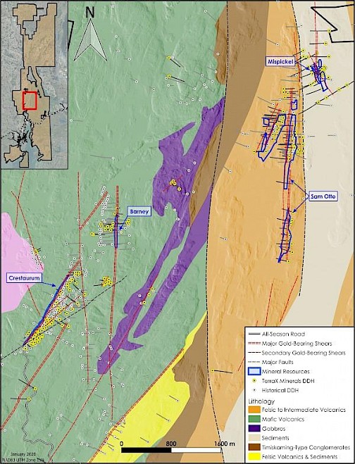
Sam Otto
The Sam Otto area is the largest gold mineralizing system found on the property to date. The dominant north-south mineralized system extends for approximately 4.5 km over widths of 80 to 130 m. With the recent completion of the drilling program at Sam Otto, Gold Terra has now completed 26,694 m of drilling in 94 holes from 2016 to 2020.
Currently the Sam Otto deposit consists of three zones – Sam Otto Main, Sam Otto South, and Sam Otto West (Dave’s Pond) which are hosted in felsic to intermediate volcanics of the Banting Formation with intercalated sediments and mafic volcanics. The Sam Otto Main and South consist of north-south trending zones of gold mineralization which are vertically to steeply east dipping and occur in discrete 2 to 20 m wide shear zones with sericite alteration and minimal quartz veining. These shear zones are crosscut by northeast structures that create significant higher grade shoots with indications of increasing grade with depth. Gold is associated with disseminated sulphides (minor to low percentages of pyrite, pyrrhotite, and arsenopyrite). Visible gold is rare and gold grades are consistent within a range of 0.5 to 5 g/t (no gold assays > 25 g/t).
The Sam Otto West zone (Dave’s Pond) trends north-northeast and consists of narrow discrete shear zones (3 to 10 m in width) of moderate to intense quartz-sericite-carbonate alteration with multi-stage quartz veining and moderate sulphides (arsenopyrite, pyrite, and stibnite) associated with the gold. Visible gold is more common and gold grades range from 3 to 15 g/t with assay values up to 30 g/t.
Sam Otto
- Currently the largest deposit of the four containing a pit constrained Inferred mineral resource of 426,000 oz gold (10,794,000 tonnes averaging 1.23 g/t) to a maximum depth of 200 m
- Highly prospective bulk tonnage target with wide shear-hosted gold mineralization traced over a strike length of 4.5 km
- 2020 drilling program successfully expanded the mineralized system, which remains open to the north, south and at depth.
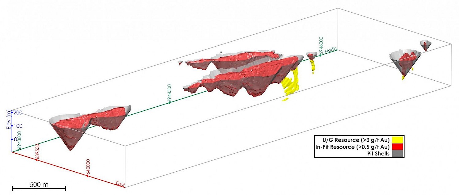
Sam Otto Pit Shell
Mispickel
The Mispickel gold deposit is contained within a wide (up to 200 m) north-south trending deformation zone that extends for at least 3 km. Two dominant shear zones (Main and Hanging wall zones) have been intersected within the wider deformation zone. Gold Terra has completed 13,026 m of drilling in 47 holes from 2016 to 2018.Mispickel
The Main zone consists of abundant narrow (1-50 cm) quartz veins commonly containing coarse-grained visible gold while the Hanging wall zone contains fewer quartz veins and less visible gold. The deformation zone that contains these two higher grade shear zones contains wider, low grade gold mineralization (approximately 0.5 g/t over widths of 47 to 78 m). There is low to moderate sulphide content consisting of arsenopyrite, pyrite and pyrrhotite within subtle chloritic to sericitic alteration. The zone is hosted in turbiditic sediments of the Walsh Lake Formation.
Crestaurum
The Crestaurum gold deposit is the most advanced target on the property. Gold Terra has completed 15,114 m of drilling in 99 holes from 2014 to 2019.
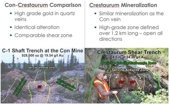
The gold mineralization at Crestaurum is very similar in style to the past producing Con Mine (1938-2003) located 15 km to the south and mined to a depth of 2,000 m below surface. The Crestaurum deposit is likely an extension of the Con vein system (Con shear zone) of the former producing Con mine (gold production from this system was approximately 1 Moz of gold). It is a lode gold style deposit consisting of quartz veins hosted within discrete sericite-chlorite-carbonate shear zones hosted in the Kam Group mafic volcanics.
The northeast trending Crestaurum shear zone has been traced over a strike length of approximately 3.5 km and ranges in width from 10 to 25 m. Historical workings (from the late 1940s) include a small exploration shaft of 128 m and two cross-cuts totaling 110 m. No past production has been recorded. Pre-Gold Terra drilling activities on the Crestaurum deposit include approximately 21,000 m of drilling in 198 holes.
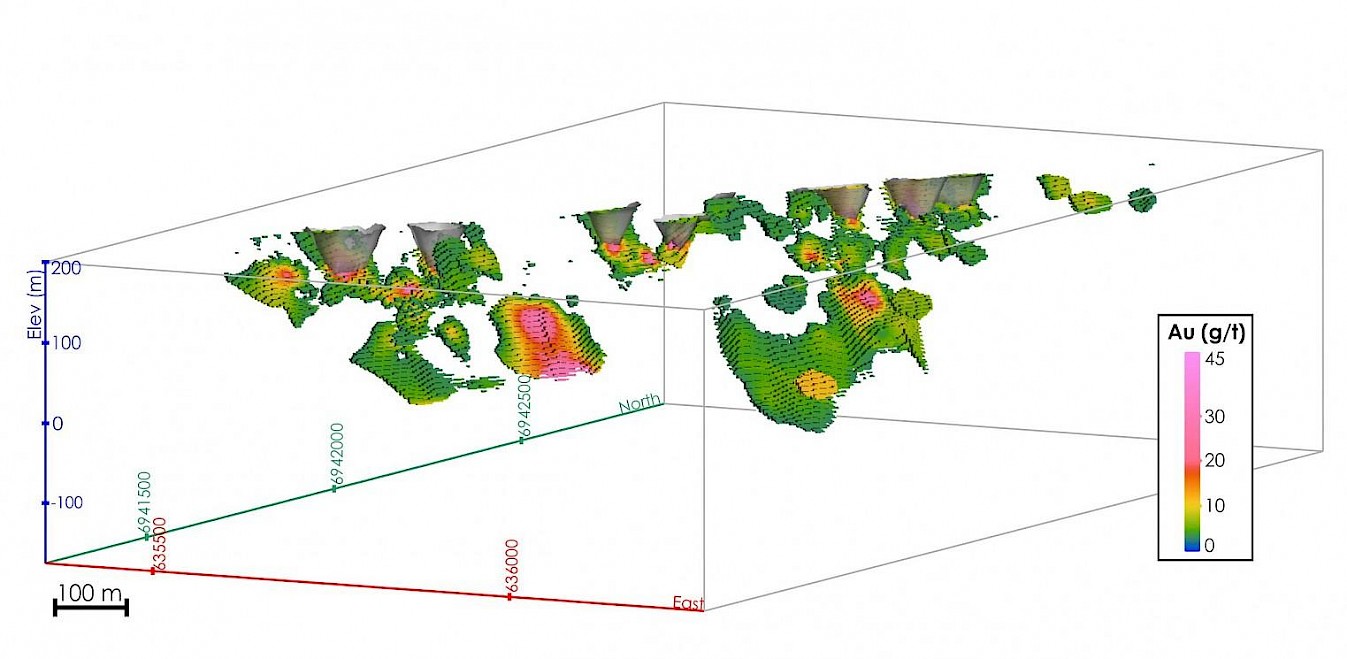
Gold mineralization is mainly hosted in multi-stage quartz veining within sericite-chlorite alteration zones that contain low to moderate sulphides (arsenopyrite, pyrite, stibnite) and local visible gold. The mineralized zones trend northeast and are parallel to the main shear zone, dipping 50 degrees to the southeast. The highest gold grades (+100 g/t) are found in 2 to10 m wide zones displaying intense sericite alteration with quartz veins that vary from less than 1 cm to 1.5 m in width. High grade shoots or lodes have subvertical plunge. Up to four shoots or lodes have been identified to date. Secondary zones of gold mineralization have been intersected in the hangingwall and footwall of the main zone, adding to the potential for further discoveries for the Crestaurum area. The mineralized zones remain open in all directions and down dip.
Crestaurum
- 3 km WSW of Sam Otto and outcropping at surface over a strike length of 1.2 km
- Crestaurum OP modeled as a shallow starter pit (high grade gold mineralization) before moving potentially into an underground operation via a ramp or shaft: current scenario estimates a pit constrained Inferred mineral resource of 38,000 oz gold (127,000 tonnes averaging 9.41 g/t) to a depth of 45 m
- Crestaurum UG Inferred mineral resource of 153,000 oz gold (723,000 tonnes averaging 6.56 g/t) defined along a strike length of 1.2 km over widths of 2 to 15 m up to a depth of approximately 300 m.
- Almost all of the inferred resource is within 100 m of surface due to lack of drilling below that depth. Remains open along strike and down plunge
Crestaurum: UG & Pit Constrained
Barney
The Barney deposit is located 1 km northeast of Crestaurum on a north-south trending deformation zone (referred to as Barney) and interpreted to be the northern extension of the Giant deformation zone (host of the former Giant mine). Gold Terra has completed 6,450 m of drilling in 26 holes from 2014 to 2016.
The Barney deformation zone has been traced over a strike length of 8 km and contains numerous distinctive shear zones with widths of up to 40 m. The shear zones contain abundant carbonate-quartz veins with moderate to high coarse grained sulphides (arsenopyrite, pyrite, and galena) and occasional visible gold. The mineralized zones are oriented north-south and have enhanced gold grade at the intersection with northeast trending structures which have an undetermined dip (possibly sub-vertical).
A felsic intrusion below the Barney shear zone is also mineralized, hosting quartz vein stockworks with carbonate-sericite alteration. Associated sulphides and precious metals include significant molybdenum, chalcopyrite and silver. A limited number of drill intersections have been obtained but there appears to be a consistent pattern of gold bearing veins within 20 m of the contact between the porphyry and the mafic volcanic rocks.
The current model for Barney has defined a small underground mineral resource over a strike length of approximately 175 m. The current resource model extends for a strike of 550 m and to a depth of 620 m but there is insufficient drilling to define higher grade mineral resources. The mineralized system remains open in all directions.